Harrow Highways
Vol 1
Vol 2
Vol 3
Vol 4
Vol 5
Vol 6
Vol 8
Vol 9
Vol 10
Vol 12
Walkabout
Laing Estates
Vintage Maps
Bus Routes
Shopping Parades
Schools
Parish Magazines
Contact me
If you're interested in the recent history of the area to the east of Weadstone, this site has some historical information about:
- a number of major streets
- extracts from sales brochures for the Laing’s estate
- vintage maps (early 1900s) of the area
- bus routes
- the unfinished Northern Line extension
- shops that once comprised our local parades.
Harrow Highways
 |
| Margaret perusing her volumes |
The ‘Contents’ page of each booklet below can be accessed from the link in its title. The material is still within copyright (life + 50 years), so only a limited number of pages can be offered on this site. A few other pages may also be available - ‘Contact me’.
Where photographs have been reproduced, they've been scanned at about 300dpi and then slightly blurred to minimise screen patterning artefacts caused by their being printed in 'half-tone’.
 Histories of Harrow Weald Highways Volume 1, Harrow Weald, Stanmore, Wealdstone (also see Volume 10)
Bishop Ken Residents Association; 1974; First Edition
Map of District
p1 - Foreword and Historical Preamble (also see Volume 10)
p5 - Kenton Lane (also see Vol 9)
p7-8 - College Road
p8 - Gordon Avenue
p12-13 - photographs
- Wealdstone, The Duck in The Pond, Belmont Halt
p16-17 - photographs
- The Hare, Grim’s Dyke Lake, German Bridge Cottages
p18-19 - photographs
- The Rose & Crown, Kenton Lane (Hill House), The Duck in Pond, and Blackberry Lane - undated, but probably from the early 20th century
p22 - Dryden Road
p23 - Old Redding
 Histories of Harrow Weald Highways Volume 2, on the Suburban Trail Again
Bishop Ken Residents Association; 1975; First Edition
Map of Estates
p1 - Foreword
p4 - The Highway
p6 - Mountside
p8 - Connaught Road
p26-27 - photographs
p36 - Harrow Weald High Road
Histories of Harrow Highways Volume 3, from the Weald to Stanmore
Bishop Ken Residents Association; 1975; First Edition
p1 - Introduction
p6 - map of farms
p17 - Belmont Circle
p20 - Old Church Lane
p23 - map
p28 - photographs - Belmont Circle, ruined St John’s
Histories of Harrow Highways Volume 4, Wealdstone and Its Victorian Highways
Bishop Ken Residents Association; 1976; First Edition
p4 - Wealdstone map
p5 - Introduction
p30 - Headstone Drive
p22-23 photos
Histories of Harrow Highways Volume 5, from Stanmore Common to Chandos Country
Bishop Ken Residents Association; 1976; First Edition
p2 - map of Church Road
p5 - Introduction
p7 - Watford Road & Stanmore Common
p15 - Elm Park
p16 - Uxbridge Road
p18 - The Broadway
p31 - Marsh Lane
p33 - Honeypot Lane
p35 - Whitchurch Lane
Histories of Harrow Highways Volume 6, Harrow on the Hill
Bishop Ken Residents Association; 1977; First Edition
Thanx for scanning this volume, Kev. Apologies for all Mediafire’s chaff.
Histories of Harrow Highways Volume 7, Exploring Historical Picturesque Pinner
Bishop Ken Residents Association; 1977; First Edition
Histories of Harrow Highways Volume 8, Down the Roman Road to Edgware
Bishop Ken Residents Association; 1978; First Edition
p4, 5 - map - featuring twelve public houses
p7 - Introduction
p12 - Edgware Road
p15 - High Street
Ten pages of photographs (Mainly public houses. Page 26 upper is Edgware Police Station officers 1920; below it is Edgware Station, Great Northern Railway - looking north-east at the pale, glazed brick, ticket office [built in 1867] in the station forecourt. The platform and tracks run from behind the ticket office towards the right. Adjacent to them, but out of view to the right, is a rectangular-tank water tower. The adequately heated, tiny building may have accommodated a weigh office.)
p31 - Whitchurch
p36 - Station Road
Histories of Harrow Highways Volume 9, Kenton Hamlet and District
Bishop Ken Residents Association; 1979; First Edition
p4 - Kenton map
p5 - introduction
and preamble
p15 - Kenton Lane (also see Vol 1)
p19 - Charlton Road
p28 - Woodcock Hill
p30 - Northwick Estate and map
Histories of Harrow Highways Volume 10, Harrow Weald Again and Hatch End (intended to replace Volume 1)
Bishop Ken Residents Association; 1980
Front cover
p2 - Acknowledgements and Guide to Photographs
p4 - Map of Harrow Weald Estates
p5 - Introduction
p7, p8, p9 - Historical Pre-amble
p15 Cedars Estate & p17 Grinling Estate
p16 Blackwell Family Tree
Histories of Harrow Highways Volume 11, Roaming Round Roxeth and Roxbourne
Bishop Ken Residents Association; 1981
Histories of Harrow Highways Volume 12, Going Back to Greenhill
Bishop Ken Residents Association; 1981; First Edition
Apologies for the Mediafire dross: Volume 12 - which has been kindly uploaded by Kev Demant… thanks Kev.
HARROW walkabout
by Elizabeth Cooper, 1973
" …in the very early 1970s there was a woman historian, Elizabeth Cooper, who hit on the idea of taking people around the Hill on escorted walks. The idea was to show people just how much there was up on the Hill that was worthy of conservation." - Don Walter
Kev Demant has uploaded this fascinating, 56-page booklet. Although intended to detail suggested walks in the Harrow area, it actually contains a mine of valuable historical information about the areas it explores: Harrow Weald, Pinner, Canons, Harrow Hill, Roxeth, Wealdstone, and Hatch End.
The Laing Estate
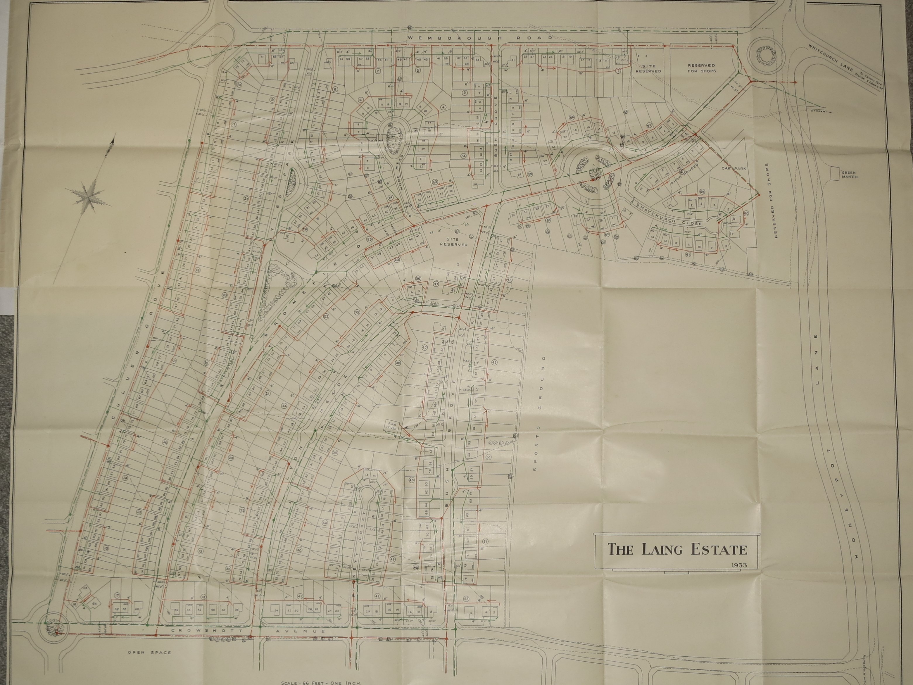
The Laing estate seems to have been sold off in 2 or 3 phases. Laing’s, the builders, bought the first parcel of land from Barts Hospital in 1931, and then had to get planning permission and pay land taxes.
Colne Valley put in a 14” water main down Honeypot Lane from Stanmore to what is now the Queensbury circle and then down Charlton Road to Kingsbury Road. An agreement with Hendon Rural District Council covered the rainwater and sewage arrangements early in 1933 for that parcel of land bounded now by Wemborough Road, Honeypot Lane, Crowshott Avenue and St Andrews Drive. Our house is on this part of the Laing Estate so our deeds concentrate on this area. Development commenced and the show houses were in the top part of Bromefield, and images in the brochures for the estate show them and others on the nearby roundabout in Bromefield. Another part of that first parcel was south and east of Crowshott Avenue and extended across Honeypot Lane, but our deed pack has no detail on that land, although it was clearly developed by Laing’s at some point.
From the various maps it can be seen how a few of the road names have changed over time (Watery Lane - Culver Grove - St Andrews Drive), intended roundabouts changed orientation and proposed future roads took a slightly different direction. And the Green Man pub had been there a very long time before its demolition for more housing. At the North Eastern end of Bromefield only some of the proposed shops were built and some of the land thus unused eventually became the Canons Community Centre. The old farmhouse was situated between what is now Bush Grove and Lyon Mead, and because the contour lines are also shown, it can be seen that this was located atop a low hill. All the foul drainage connections are shown and it can be seen that the connections start at one house, run behind a number of others and then into the main sewer - all naturally downhill. 63 local drains (all numbered) connected the houses to the main sewers. Foul sewers are coloured red, while rainwater sewers coloured green ran at the front of the houses.
Our house was a Rona de-luxe or type RA, and first sold in 1935 for £750. We had also been left, by the previous owner, an architect’s cloth drawing of the Rona RA house type, annotated for the construction of a garage in 1949. But the original detail is all there, with room dimensions (non-metric of course) and construction details clearly visible.
If you bought your home before 2003, your deeds will have contained similar details, and if you do not have them, they may well be lodged with your bank. But after that date, the Land Registry went digital and your original paper deeds may have been destroyed as no longer needed.
Graham and Jeanette Hall, 2020.
Laing Sales Literature
Pages from two brochures, undated - but believed to have been printed in about 1934, promoting Laing homes. (Retained and loaned by Chris Cartwright who was raised in Lamorna Grove [close to Chandos Secondary] by his parents who bought their Laing home in about 1937.)Omitted pages either detail more styles of Laing’s houses - or duplicate existing text.
 |
Canons Park, Edgware Page: 1 (front cover), 2, 3, 4, 6 and 7 - sketch map of the estates and their environs (spot the premature assumptions, the LNER Station… and the tram stop), house-style price list, 10 (including a photo of Camrose Elementary), and back cover. |
 |
Canons Park Estate Page: front cover, 4, 5, 12 (incl. photo of Canons Park parade), 13 (incl. Canons Park Metropolitan Station). |
Heating our Laing home - before central-heating
Our house had two downstairs hearths, one in each of the two downstairs living rooms, and one in each of the two larger bedrooms. A pair of hearths (an upstairs and a downstairs) fed into a breast. Just below roof-level, the two breasts combined into a single, four-flue stack. We had grates downstairs and in one of the bedrooms - and burned coal - never coke or wood.
Coal was considered expensive, so my father only ever lit one of the two downstairs grates at any time and, rarely, the bedroom grate.
A downstairs grate would be lit in the afternoon. Dad’s technique for lighting the upstairs fire was "brave". He would use a red-hot coal transferred from the lit downstairs fire. Following the inevitable dropping of the glowing coal as he transported it upstairs - and the ensuing singeing of the carpet - my mother forbade him from lighting the upstairs grate again.
Eventually, we used a single, portable, Aladdin ‘Pink’ paraffin (a BP brand) heater to share between the bedrooms. The heater was refilled from a 1 gallon portable container initially (‘charged’ at Belmont Catos) … subsequently we employed a five gallon storage tank stood in the garden.
As purchased, our home included an exterior, brick-built coal-bunker, but Dad dismantled it as he wanted to build a shed on that spot. Instead, he bought and erected two concrete pre-fabricated bunkers, positioning them rather closer to the back door than the original bunker. I was the only one in our household small enough to climb into the bunkers (to attach the nuts onto the fixing bolts) through the filling hatch on top.
My mother didn't altogether trust tradesmen, so I was tasked with counting the number of sacks that coal-men actually delivered.
Hot water was heated by a back-boiler in a coal-fired stove mounted in an outside corner of the kitchen (so it could have its own external flue). Heated water circulated, by gravity (convection), to a directly heated (no coil) sealed, copper storage-tank in the corner of the bathroom with an airing cupboard ‘boxed-in’ around it. Pipework was copper.
We also used a portable, upright, two-bar electric fire stood on the hearth of one of the living rooms - but electricity, as now, was considerably more expensive for heating than coal.
Town-gas (coal-gas) entered the house through a 1" main under the stairs. Every room, including the bathroom, was skeletoned with steel gas piping supplying a gas outlet (which, in our house, were all capped-off). The two downstairs living rooms also had bayonet connector outlets Tee-ed off below the room’s capped-off outlet. Bayonet outlets, mounted on skirting boards, were intended for gas pokers and portable gas appliances. But we didn't use any gas appliances.
Eventually, my father had town-gas central-heating installed.
E. B., 2011
Vintage Maps of the Area
Hatch End 1891 and its environs (O.S.)
It's surprising just how un-developed the area was 130 years ago.
and this image:
Chandos School (Stanmore) and its environs c.1945. It looks like there were only two huts on the school site at the end of the war, both running longitudinally. Later (possibly the late ’40s) the upper (easterly) hut was supplemented by a second one and the lower hut was supplanted by a pair running laterally (north-south). Three of them were used by girls, and one by boys… but what are those lighter strips where the Park Block was subsequently built? Air-raid shelters?
Amongst his paraphernalia, Gareth Peach (formerly of Wellington Road, Wealdstone) discovered this fascinating, undated map showing Harrow and its sparsely populated environs. Since "London Aerodrome" has been designated at Colindale, and that wasn't established until late 1910, the map probably dates from then. (An early London Airport was built at Croydon.):
Bacon's Map of the Environs of London N.W. on Cloth 1s. net, (the 'extract’ reproduced here covers about a quarter of Gareth’s map.)
London: G. W. Bacon & Co., Ltd., 127 STRAND
Scale: squares are 3 miles per side.
The estates on which most of us were brought-up? … The parades at which we shopped? … Nowhere. It took the expansion of the Metropolitan Railway around 1900 and a bold, new marketing strategy in around 1915, to stimulate their inter-war development and release inhabitants from the privations of rented, London properties.
London Transport Road Services - Harrow and District - 1940/50s
| from Kemp’s Steet Directories for Harrow | |||
| Route | Day of Week | Terminal Points | via |
|---|---|---|---|
| Buses | |||
| 18 | Mon./Sat. | Aldenham - Wembley | Edgware, Sudbury Town |
| 18 | Sunday | Edgware - London Bridge | Wealdstone, Wembley, Harlesdon, King’s Cross |
| 79A | Daily | Northolt - Edgware | Alperton, Wembley, Kingsbury |
| 98 | Daily | Hounslow - North Harrow | Hayes, Ruislip, Pinner |
| 114 | Daily | Rayners Lane - Edgware | Harrow, Stanmore |
| 140 | Daily | London Airport - Mill Hill | Hayes, Yeading, Northolt, Harrow, Kenton |
| 142 | Mon./Sat. | Kilburn Park - Watford | Cricklewood, Hendon, Edgware, Stanmore, Bushey |
| 142 | Sunday | Edgware - Watford | Stanmore, Bushey |
| 158 | Daily | Ruislip - Watford | South Harrow, Harrow, Bushey Heath |
| 183 | Daily | Golders Green - Northwood | Hendon, Kenton, Harrow |
| 187 | Daily | South Harrow - Hampstead Heath | Alperton, North Acton, Harlesdon, Maida Vale |
| 209 | Mon./Sat. | Harrow Weald - South Harrow | Pinner |
| 220 | Daily | Uxbridge - Northwood | Ickenham, Eastcote |
| 230 | Daily | Rayners Lane Station - Northwick Park Station | Weadstone, Kenton |
| Coaches (Green Line) | |||
| 703 | Daily | Wrotham - Amersham | North Harrow, Pinner Green, Northwood |
| 706 | Daily | Aylesbury - Westerham | Bushey, Stanmore, Edgware |
| 707 | Daily | Aylesbury - Oxted | |
| 708 | Daily | East Grinstead - Hemel Hempstead | |
| 719 (from 1956) | Daily | Victoria (later Wrotham) - Hemel Hempstead | Bushey, Stanmore, {along Honeypot Lane to:} Kingsbury |
| Routes serving fringe areas | |||
| 92 | Daily | Wembley - Ealing Hospital | Wembley Empire Pool, Sudbury, Greenford |
| 92A | rush hours | Wembley - Ealing Hospital | Wembley Trading Estate |
| 107 | Queensbury Station - Enfield Lock | Edgware, New Barnet, Elstree, Borehamwood | |
| 107A | Queensbury Station - Enfield Lock | ||
| 306 (coach) |
New Barnett Station - Leavesdon | Barnet, Arkley, Borehamwood, Elstree, Bushey Heath, Bushey and Watford | |
| 709 (coach) | Daily | Chesham - Caterham | Gerrards Cross, Uxbridge and Oxford Circus |
| Trolleybuses - trolleys replaced trams in the mid-1930s… more - but they did required additional electrical infrastructure in the street (two overhead conductors - as opposed to the tram’s single overhead wire. (Trams’ metal tyres completed the ‘return’ circuit via the rails). | |||
| 645 | Barnet - Canons Park (the formal, Stonegrove entrance to the Canons Estate) | High Barnet Station, Great North Road, North Finchley, Church End, Golders Green, Cricklewoood, Hendon, Colindale and Edgware | |
| 664 | Paddington - Edgware | Harrow Road, Willesden, Cricklewood, Hendon | |
| 666 (replaced the 664) |
Edgware (Station Road) - Hammersmith Broadway | Burnt Oak, Colindale, West Hendon, Staples Corner, Cricklewood, Willesden, Church Road, Harlesden, North Acton, Acton, Acton Vale and Starch Green, with additional Monday to Saturday rush hour journeys between Harrow Road (Scrubs Lane) and Acton (Horn Lane) | |
| Trams (The position of a tram stop [an early terminus?] in Edgware High Street is marked on the map in the Laing brochure, pages 6 and 7 - see above.) | |||
| 64 (broadly replaced by trolley 664) | Weekdays only | Edgware (High Street) | Cricklewood – Hendon – Edgware |
| 66 (broadly replaced by trolley 666) | (Known as ‘country trams’, the vehicles were initially open-topped: later the upper deck was enclosed except for the two ends at the top of the stairs. - H/H Vol. 9) | Acton - Harlesden - Cricklewood - Hendon - Edgware - Canons Park (extended along Stonegrove to Canons Corner in 1907 - Canons Park Station, initially serving the Metropolitan Line, wasn't opened until 1932) | |
The Northern Line Extension (to the north)
 During World War II, London Transport’s Aldenham Bus Works (seen here in 1956), originally planned as a construction depot for the proposed extension of the Northern Line to Elstree, was used for manufacturing Halifax bombers. During World War II, London Transport’s Aldenham Bus Works (seen here in 1956), originally planned as a construction depot for the proposed extension of the Northern Line to Elstree, was used for manufacturing Halifax bombers.Eventually the buses that Aldenham produced were able to benefit from aircraft manufacturing technology e.g. aluminium monocoque construction. |
‘Northern Heights' arch-iology